History
Eleanor:
There was a time in what was then western Virginia when huge tracts of land belonged to none other than the future father of our nation, George Washington. One of those tracts eventually became the site of what is now the town of Eleanor.
For the most part, Eleanor has been a rather quiet community, but one with an interesting history that began during a very dark period of the United State, the Great Depression, which lasted the entire decade of the 1930s.
In 1934, 150 families moved to Red House Farms, a federally-owned and planned New Deal Resettlement Community. The original homesteaders paid rent, grew their own gardens, and worked in local industry or agriculture seeking to achieve self-sufficiency. Utilities, services, a school, recreation facilities, and medical clinic were also developed. At the center of the community was the Red House or Ruffner House, circa 1840, which served as the administrative building.
So how did Red House Farms become known Eleanor? First Lady Eleanor Roosevelt was a fierce advocate of Resettlement Communities and visited on up to five occasions. She was known to spend time playing with the children and handing out chewing gum. So, in a short time, the community was renamed to honor Mrs. Roosevelt.
With the Great Depression and World War II behind the nation, in 1946 the community began to move towards privatization, and many who had rented for years were able to begin purchasing their homes. In 1966, Eleanor was formally incorporated as a West Virginia town.
In order to experience a measure of Eleanor’s history, visitors can visit a museum in the Red House, which is now the town hall, or drive the streets to view some of the 146 original homes that still exist. The town has also purchased one of the homes, which is being restored as a museum.
Winfield:
At the founding of Putnam County in March 1848, the site on which the town of Winfield now is located was chosen as the county seat. Previously much of the land was owned by Charles Brown, who operated a ferry across the Kanawha River. He donated the land for the courthouse, which was completed in 1849, the same year the town was named for General Winfield Scott, commander of American troops during the Mexican War.
With its location on the Kanawha River, Winfield became a strategic site during the Civil War; whoever who controlled that section of the river controlled boat traffic. The most notable skirmish between Union and Confederate units took place in October 1964. The leader of the Confederates, Captain Philip Thurmond, was killed and buried in an unmarked grave. His remains were located in 2010 and placed at a site behind the Putnam County courthouse.
In 1868 following the war, Winfield was incorporated. Thirty years later during a powerful windstorm, the courthouse was destroyed. A new courthouse was built in 1900 and is part of the larger courthouse annex built in 1998. Other important events in the history of Winfield include a large fire in 1928 that destroyed an entire city block, the paving of an access road to Winfield in 1930, and the construction of the Winfield locks and dam in 1936.
There are three structures in Winfield that are on the National Register of Historic Places: the main courthouse (1899), historic James W. Hoge House (1837), and the Kanawha River bridge (1957).
Buffalo:
With a local claim that Buffalo is the most historic town in Putnam County, it is commonly asked, “Is that true?” Sometimes those type of claims can be hard to prove, as history can be a collection of hard research and speculation—and, as is common in Appalachia, is steeped in oral tradition.
Whatever the case, Buffalo has a very interesting history, starting with the area having been the location of a large Native American “town.” Much of that was confirmed through an archeological dig during the mid-1960s. At the eastern edge of Buffalo, an excavation revealed a town did exist during what is known as the Fort Ancient Period (1300-1600), although it’s undetermined whether the occupants were Shawnee or a combination of tribes. This archeological site in listed on the National Register of Historic Places. It is very likely that other Native American settlements in what is now Buffalo pre-dated this, going back as many as 3,000-4,000 years.
By 1770, George Washington had surveyors in the region. One of his descendants,
William Kennarly Craig laid out the area, and Buffalo came into being through its charter in 1837. This was the first town in what is now Putnam County.
In 1849, a group of local citizens founded the Buffalo Academy, which became the center for liberal arts education not only for Buffalo, but also the region. With the coming of the Civil War, many of the young men entered the service and the school closed. At that time, during different periods it was occupied by both the Union and Confederate armies and used as a headquarters, barracks, and hospital. The academy, along with the Buffalo Presbyterian Church and Buffalo Methodist Church, form the Buffalo Historic Square, which is recognized on the National Register of Historic Places. The churches are also included in the West Virginia Civil War Trail.
Not only does the history of Buffalo include physical places of historic interest, but it also has its own characters of history. Two of the most notable are William Hope “Coin” Harvey and Confederate General John McCausland.
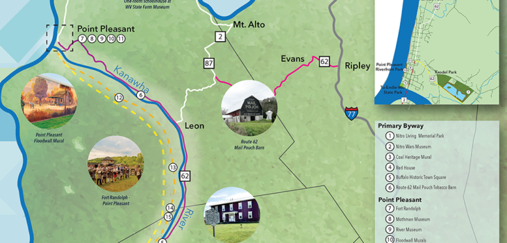
Point Pleasant:
In 2002, the Mason County Tourism Committee chose a brand for Point Pleasant: “Point Pleasant, Where Rivers and History Meet.” With its location at the confluence of the Kanawha and Ohio Rivers, it is one of the most striking sites along Rivers to Ridges Heritage Trail. Native Americans called the area Tu Endie Wei,which translates to mean“mingling of the waters” or “where two rivers meet.” It is, however, not only a site of beauty, but also a very historic place.
It only takes a good historic imagination to think what this place must have been like in the middle of the 18th century. It was the edge of the western frontier and being settled by rough and rugged frontiersmen and their families amid constant struggles that not only included the wilds, but also between the royal powers of England and France and an ongoing battle with various Indian nations. This reached a peak from 1756 to 1763 during the French and Indian War, which placed the frontier settlers on the side of the British.
Fast forward to October 10, 1774, and the settlers found themselves involved in what became known as Lord Dunmore’s War and the Battle of Point Pleasant. Some argue that battle represents the first battle of the American Revolution as it helped stir the pot to set the colonies in a position to move toward declaring their independence from Britain.
While the Revolutionary War continued until 1783, settlement of the area was well underway by 1781. This was in part due to the construction of Fort Blair and later Fort Randolph. In 1795, the settlement was recognized as a town by the Virginia General Assembly and named Point Pleasant.
As the nation grew during the 19th century, so did Point Pleasant. With its location on two large rivers, it built up a history of boat construction, a port for sternwheelers, and businesses serving the local population and river travelers. It also had its share of river disasters and floods. The boat and ship building industries continued into the time of World War II. During the Civil War, April 2, 1863, Union forces in the area turned away an attack by Confederate soldiers in what became known as Jenkins Raid.
Today Point Pleasant is well-prepared to share its history with those living in the region and travelers alike. From Tu Endie Wei State Park at the confluence of the Kanawha and Ohio Rivers, through the business district, and into its downtown residential area, the Point Pleasant Historic District is included in the National Register of Historic Places. Outside of the floodwall along the Ohio River is a beautiful riverfront park that includes world-class murals depicting the local history. Point Pleasant is home to the only river museum in West Virginia and a replica of Fort Randolph is located at Krodel Park. The West Virginia State Farm Museum is located just four miles north of Point Pleasant.